Story Map »Shore Erosion«: Slide 3
Why Do Shores Erode?
Environmental factors continuously shape the landscape, with physical properties playing a key role in shoreline retreat. Changes in these factors can accelerate erosion, further transforming the terrain.
Site-specific factors, such as backshore height, influence erosion but vary from location to location. Physical factors, in particular, are dynamic over time as they result from multiple interconnected components. For instance, storm intensity is influenced by air temperature, spatial temperature variations, and landscape morphology, all of which contribute to the ever-changing nature of coastal erosion.
Coastal erosion
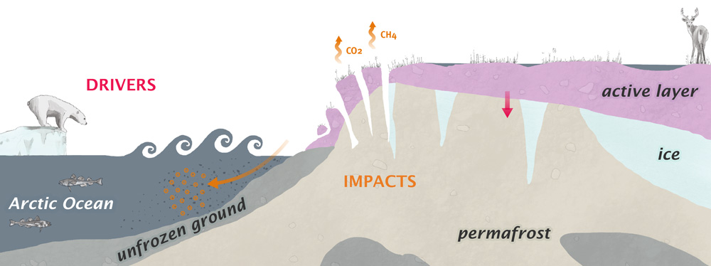
Site-specific parameters of coastal erosion include backshore height and ground ice extent. In addition to permafrost warming and thawing, physical erosion drivers involve more frequent and intense storms. Other factors include sea level rise, increased air and sea surface temperatures, and reductions in sea ice extent, thickness, and its duration along the coast. ? ? ?

Figure: Impacts and driving forces on coasts in a warming Arctic. Hover over the colored circles (divers: red, impacts: orange) for more information. ?
River erosion
The physical process of river erosion is similar to coastal erosion, though some key drivers differ. River erosion depends on site-specific parameters, including the timing of river ice breakup and freeze-up, the length of the open water season, shore height, ground ice content, and the presence of bedrock. Physical drivers, such as more frequent and intense storms, permafrost warming and thawing, and changes in runoff magnitude and timing, also play a role. However, the main drivers of river erosion are hydrological changes, particularly high seasonal discharge or extreme flow events. ? ?
Erosion and greenhouse gases
Erosion mobilizes organic matter, such as partly decomposed grass or moss, stored in permafrost. When this organic matter is exposed to microbiological and photochemical transformations, it releases greenhouse gases. This process is particularly pronounced when the organic matter is transported into aquatic systems, including lakes, rivers, and the coastal ocean, where microbial activity accelerates decomposition. ?
River erosion in the Lena Delta, Russia
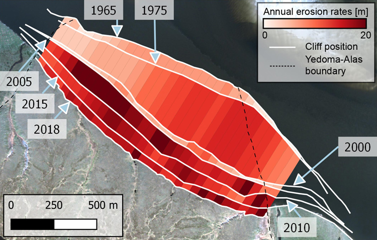
Annual erosion rates at Sobo-Sise Cliff, Lena Delta, Russia (click to enlarge)
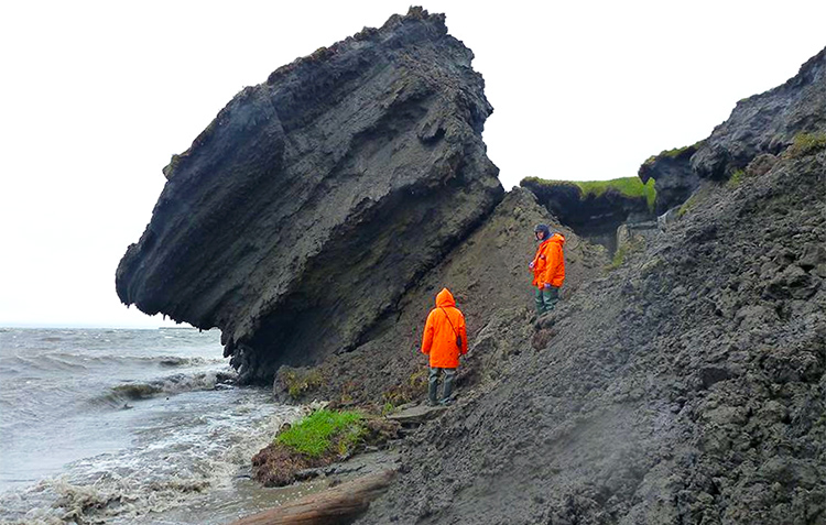
Collapsing sediment block at the Sobo-Sise Cliff (G. Grosse, 2014) (click to enlarge)
In the Figure to the left (click to enlarge) you can see annual erosion rates per segment at Sobo-Sise Cliff in the Lena Delta, Russia. The time periods are 1965–1975, 1975–2000, 2000–2005, 2005–2010, 2010–2015, and 2015–2018. The satellite image in the background is from Maxar’s GeoEye, dated 2014-08-07. The picture to te right shows a collapsing sediment block at the Sobo-Sise Cliff (12 August 2014).
Further reading
Jones B. et al. (2020): Coastal Permafrost Erosion. 2020 Arctic Report Card. National Oceanic and Atmospheric Administration (NOAA). DOI: https://doi.org/10.25923/e47w-dw52


